
Did you know that the deserts cover about one-third of the Earth’s land surface area. But the deserts of the world are much more than just the sandy, lifeless dunes of storybooks. The deserts found on Earth are extremely diverse, each unique in their own way. The dunes of the Saharan Desert, the icy tundra of Antarctica, and the Pacific coastline of the Atacama Desert are all deserts. That is right; they are all scientifically classified as deserts despite their differences. But it is quite simple, really, as they all share one common trait that qualifies them as a desert region: they all receive less than 10 inches (250 mm) of rainfall a year.
Because of the diversity of deserts under this definition, they have been split into sub-regions: Sub-Tropical Deserts, Cool Coastal Deserts, Cold Winter Deserts, and Polar Deserts.
DESERTS OF THE WORLD MAP
| Subtropical | Deserts | Costal Deserts | Cold Deserts | Polar Deserts |
| Sahara | Gibson | Namib | Great Basin | Arctic |
| Arabian | Great Sandy | Atacama | Colorado Plateau | Antarctic |
| Kalahari | Great Victoria | Patagonian | ||
| Mojave | Tanami | Karakum | ||
| Sonoran | Sturt Stony | KyzlKum | ||
| Chihuahuan | Simpson | Taklamakan | ||
| Thar | Gobi |
SUBTROPICAL DESERTS OF THE WORLD
Sub-tropical desert regions are responsible for a significant portion of land on this planet. These regions are characterized by mostly warm to very hot temperatures with cooler winters. These areas tend to be landlocked and receive extremely low amounts of rainfall. The temperature usually fluctuates widely just during the course of a day, moving from extremely hot to cold in a matter of hours. These deserts tend to have very few plants and animals, and those that remain have adapted to the coarse, dry soil and the ever-present wind.
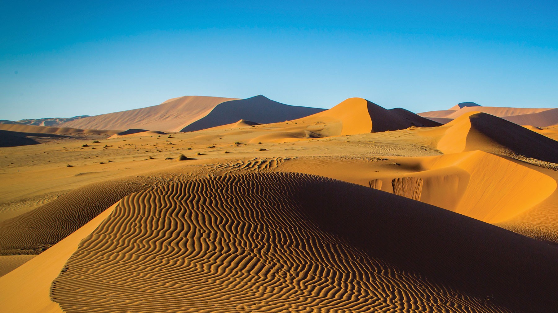
SAHARA DESERT
Of the deserts of the world, the Sahara Desert is the largest desert that falls into a sub-tropical climate. The Sahara covers most of northeastern Africa which is about 10% of the continent. It is nearly as large as the United States in terms of land area. It can take upwards of a week to cross this desert by car and more than 40 days walking! Though the Sahara is expansive, it is technically is the 3rd largest desert after Antarctica and the Arctic. The Sahara extends from the Atlantic Ocean in the west to the Mediterranean in the north to the Red Sea in the east. There are 10 countries in Africa that have some part of their nation in the Sahara desert. The Sahara has some of the largest sand dunes in the world. Some can reach nearly 600 feet (183 meters) tall. Though movie productions may have convinced us otherwise, only one-fourth of the Sahara terrain is actually comprised of sand dunes. The average temperature in the Sahara is a comfortable 86°F (29°C), but can reach as high as 120°F (49°C) in hottest months of the year. If that isn’t hot enough for you, the record temperature was reported at a steamy 136°F (58°C)!
ARABIAN DESERT
The Arabian Desert is named after its location as it makes up nearly all of the Arabian Peninsula, which includes the countries of Qatar, Yemen, Oman, United Arab Emirates, Kuwait, and Saudi Arabia. In the center of the Arabian Desert, you will find Earth’s largest area of unbroken sand called Rub’al-Khali. The rest of the desert is made up of gravel plains and rocky hills. It also includes natural occurrences of the notorious and lethal “quicksand.” The Arabian Desert borders the Nile River Valley on its west side and the Gulf of Suez on the eastern end, which makes it essentially surrounded by water on all sides with the exception of the northeast corner that connects it with the Asian continent.
KALAHARI DESERT
The Kalahari Desert is unique among the subtropical deserts. It happens to get significantly more rainfall and support more diverse life than its counterparts. It receives nearly double the rainfall (5-9 inches annually) of the Arabian and Sahara desert, yet portions of the Kalahari still meet the definition of a desert in terms of rainfall. It covers most of the African nations of Namibia, Botswana, and portions of South Africa. The Kalahari is approximately 600 miles (966 km) wide and 1,000 miles (1,609 km) north to south. Within the expanse of the Kalahari Desert, you will find the Central Kalahari Game Reserve – the second largest protected area for wildlife in the world.
MOJAVE DESERT
The Mojave Desert can be found in the southwestern United States covering portions of southern Nevada and southeastern California. The Mojave Desert contains the infamous Death Valley, known for being the lowest point, driest location, and hottest area on the North American continent. The weather there is characterized by extreme heat and cold. It can drop below freezing and exceed 75°F (23°C) in a single day. The record high for the Mojave is 134°F (57°C). The record cold temperature reached was 15°F (-10°C)!
SONORAN DESERT
The Sonoran Desert is located in the southwestern part of the United States reaching into northwestern Mexico. It is the hottest desert in the North American continent with air temperatures consistently rising above 118°F (48°C). The Sonoran Desert is a vast expanse of over 100,000 square miles (259,000 square km) of area. It also happens to host an extremely diverse lineup of wildlife. There are over 65 mammals, 340 birds, 100 reptiles, and 2,500 species of plants across the region. The Sonoran Desert is the only place in the world you can find a naturally occurring Saguaro Cacti, which can live for over 200 years!
CHIHUAHUAN DESERT
The Chihuahuan Desert is the largest desert in the North American continent. It has a land area of over 390,000 square miles (1,010,095 square km) across the southern United States (30%) and Northern Mexico (70%). The Chihuahuan Desert reaches into Texas, Arizona, and New Mexico in the US and Chihuahua, Durango, Coahuila, Zacatecas, and Nuevo Leon in Mexico, which accounts for approximately 1.5% of the land area on the North American continent. It is considered a “rain shadow desert,” which means that mountains that lay on the outskirts of the desert block much of the precipitation from entering. This area is renowned for its high diversity of cacti with over 300 species found in within its boundaries.
THAR DESERT
The Thar Desert is also known as the Great Indian Desert and lies in the northwestern part of India – predominantly in the Royal Rajasthan states. It is the 7th largest sub-tropical desert and the most sparsely populated region in India. Even so, the Thar Desert is the most densely populated desert in the world. Because of the increase in population in the area, the Thar Desert is home to a series of festivals every year which are celebrated with music and dance. The desert is uniquely home to five salt water lakes that mark the landscape.
AUSTRALIAN DESERTS
Australia is home to a wide range of desert areas due to its unique geographical features and climate. Two-thirds of the Australian continent is considered arid or desert, which makes the continent the driest on Earth after Antarctica. When you consider all the deserts of the world, Australia does not have the largest desert areas, but they do have the most desert areas of any continent when compared to the total continental surface area. There are 10 different deserts on the continent of Australia. Many are adjoining and some even overlap. They include the Great Victoria Desert, Great Sandy Desert, Tanami Desert, Simpson Desert, Gibson Desert, Little Sandy Desert, Strzelecki Desert, Sturt Stony Desert, Tirari Desert, and Pedirka Desert. Not all are covered in the following information due to their resounding similarities to each other.
GIBSON DESERT
The Gibson Desert can be found in the central part of Western Australia. It happens to be one of the smaller deserts in Australia, coming it as the 5th largest. It is highly regarded for its “untouched” state as a result of it being largely uninhabited even to this day. Most of the human population living in the Gibson Desert is part of the aboriginal tribes of Australia. The Gibson Desert currently is home to five different types of animals that are on the endangered species list.
GREAT SANDY DESERT
The Great Sandy Desert is the second largest desert of Australia. It is located in the northern section of Western Australia, just south of the coastline. The Great Sandy Desert is home to the Kata Tjuta – Uluru, otherwise known as Ayers – a world heritage site. Ayers Rock is a huge sandstone formation that extends almost unexplainably from the flat desert to a mountain-plateau that reaches 1,150 feet (350 m) into the sky. There are also some very unique plants in the Great Sandy Desert, including the Desert Bloodwood – a mid-size tree that has blood-like sap and leathery leaves. But it has not always been great for wildlife in this desert. Invasive species have long been a problem. Nearly 100 years ago, the Australian government built a fence around the Great Sandy Desert to try to keep out invasive species such as rabbits, fox, and cats. At the time, it was the longest fence in the world and portions of the fence are still visible today.
GREAT VICTORIA DESERT
The Great Victoria Desert is the largest desert in Australia and the 3rd largest sub-tropical desert in the world after the Sahara and Arabian. It one of the least populated areas in the southwestern part of Australia. The Great Victorian Desert is surrounded by the Gibson Desert to the North, the Little Sandy Desert to the northwest, the Simpson and Sturt Stony Desert to the east, and plains to the south. The Great Victorian Desert does not resemble what many think of as a desert. It qualifies due to a lack of rainfall, yet you will not find endless sand dunes or barren plains there. There is a significant amount of vegetation and wildlife present in the Great Victorian Desert which is what makes it such a visited location by tourists.
TANAMI DESERT
Of the deserts in Australia, the Tanami Desert is the third largest. It is located in the northern territory in the central part of Australia. It is found just east of the Great Sandy Desert. There is a stretch of road that stretches over 600 mi. (1,000km) and attracts four wheel drive enthusiasts from across the globe called the Tanami Track. It is also heavily used by the mining industry as the Tanami Desert is rich in natural resources. Like many of the other deserts across Australia, this desert is home to many endangered plants and wildlife such as the Wallaby and Mulgara.
STURT STONY DESERT
The Sturt Stony Desert is located in the northeastern part of South Australia. It is surrounded by the Simpson Desert to its west, the Strzelecki Desert to the southeast, and the Tirari Desert to the southwest. The Sturt Stony Desert is characterized by its “gibber desert.” A gibber desert is one that is covered by a crowded surface of stones with shiny tops. The tops of these stones are glazed slowly over time by the constant movement of sand across the stone due to wind. Though gibber deserts are not unique to Sturt Stony Desert, the Sturt Stony is by far the most prominent area in the world in which the phenomenon occurs.
SIMPSON DESERT
The Simpson Desert is yet another sparsely populated area in central Australia in the eastern half of the continent. It happens to be one of the driest deserts in Australia. It receives just 5 inches (125 mm) of rain annually. Even so, the area benefits from its geography when it comes to water. Flooding in adjoining areas funnels the water into the Simpson Desert region giving it a significantly higher amount of water to support its wildlife. It also happens to be one of the last places in Australia that certain endangered animals call home. The fat-tailed marsupial mouse is extremely rare and largely found in this area of Australia. The Simpson Desert also has a unique geological feature: It possesses the longest parallel sand dunes found anywhere on earth. Some can be up to 125 miles (201 km) long!
COASTAL DESERTS OF THE WORLD
Cool coastal deserts are found in more moderately cool to warm climates. These areas tend to have mild, cool winters and prolonged, moderate summers. They can usually be found near large bodies of water and/or mountainous regions. Cool coastal deserts do not have the stereotypical cues of a desert, but they are some of the most harsh and arid regions on Earth.
NAMIB DESERT
The Namib Desert is classified as a coastal desert and is located in the southern part of Africa. It occupies 1,200 miles (2,000 km) of coastline in the countries of South Africa, Namibia, and Angola. It is widely accepted that the Namib Desert has had a similar arid climate for more than 50 million years, which would make it the oldest desert on Earth. The Namib features gravel plains, mountains, and sand dunes. The sand dunes can grow as high as 1,000 feet tall (302 m) and be more than 15 miles long (30 km). This area is almost entirely unsettled by humans. The Namib Desert gets less than 0.4 inches (10 mm) of rain a year, making it one of the most rain-starved areas in the world!
ATACAMA DESERT
The Atacama Desert is located on the continent of South America and is largely inside the country of Chile. It is a plateau stretching 600 miles (966 km) along the Pacific Ocean. The Atacama Desert is the driest desert on Earth after Antarctica and the Arctic. It receives just 0.04 inches (1 mm) of water per year! The Atacama is so arid and desolate that NASA uses this area to test equipment to be used on missions to Mars. Its unique geographical profile creates this arid environment from the “rain shadow” effect. The Andes mountains block moisture on one side and the Chilean Coast range of mountains block it on the other. The result is a virtual shadow where no rainfall can be created, making it extremely difficult for any plants or animals to flourish here.
COLD DESERTS OF THE WORLD
Cold winter deserts are also commonly referred to as semi-arid deserts. But don’t be fooled by the cold in the name; cold desert climates can still host the hot, dry summers of their hot desert counterparts. Cold winter desert summers are long and dry, and though not as hot as the subtropical deserts of the world, they are not cold year-round like the polar deserts. But these deserts do have cold, dry winters – sometimes with temperatures brutally below the freezing point! These cold winter deserts are generally found at higher altitudes and in temperate zones where they can be found in the rain shadows of high mountains.
GREAT BASIN DESERT
The Great Basin Desert is the largest desert in the United States occupying approximately 190,000 square miles (490,000 square kilometers). Covering much of the southwestern US, the Great Basin desert borders the Sierra Nevada Range on the west and the Rocky Mountains to the east. To the north lies the Columbia Plateau – an expansive flood basalt plateau that covers the US states of Washington, Oregon, and parts of Idaho. To the south, you will find other, smaller deserts of the southwestern US: the Mojave and Sonoran. The Great Basin exists primarily as a result of the great mountains that surround it, which cool the air and strip it of its moisture. It is a cold desert mainly as a result of its elevation and latitude. Its 7-12 inches of annual participation primarily fall as snow – even in the warm summers! The Great Basin is also home to the world’s oldest living organisms according to the National Park Service: 5,000-year-old trees called bristlecone pines.
COLORADO PLATEAU DESERT
The Colorado Plateau is largely made up of desert, which covers 130,000 square miles (337,000 square kilometers) of the southwestern United States. The Colorado Plateau, also referred to as the Colorado Plateau Province is roughly centered on what is known as the Four Corners region of the US: the point where the southwestern corner of Colorado, southeastern corner of Utah, northwestern corner of New Mexico, and the northeastern corner Utah meet. It is the only area of the United States where the boundaries of four states touch. The plateau is a geologic enigma, remaining intact while punctuated by high mountain ranges and cut by low river canyons. Though the Colorado Plateau contains desert climates with warm summers and frigid winters, it is also scattered with areas of forest. But the most famous feature of the plateau is the Grand Canyon, which has had a large hand in shaping the landscape of the “Red Rock Country” region.
PATAGONIAN DESERT
The Patagonian Desert is the 7th largest desert in the world, covering 260,000 square miles (673,000 square kilometers) – the same size as the US state of Texas! It spans much of the country of Argentina with small parts residing in Chile. To the west of the great desert are the Andes, the longest continental mountain range in the world. To the east lies the Atlantic Ocean. The Patagonia Desert is truly a cold winter desert experiencing about seven months of winter and with temperatures that rarely exceed 53.6°F (12°C) and average only 37°F (3°C). Nightly frosts are not uncommon year-round. As is the case for most cold winter deserts, the Patagonia Desert exists because of the Andes mountains, which prevent the flow of moisture from the Pacific Ocean to the west and cause the formation of the arid desert climate. In fact, before the Andes were formed, the desert was likely covered by temperate forests as evidenced by the petrified forests found in the desert’s center. Much of the desert’s landscape is continuously sculpted (and re-sculpted) by the force of the wind, which also makes it the largest source of dust over the south Atlantic Ocean!
KARAKUM DESERT
The Karakum desert is known by many names including the variation in spelling, Kara-Kum, and even Gara Gum in Turkmen and Karakumy in Russian. Its name means “black sand” in Turkic languages. The desert inhabits about 70 percent, or 135,000 square miles (350,000 square kilometers), of present day Turkmenistan in Central Asia, east of the Caspian Sea. The shrinking Aral Sea lies to the north of the desert, expanding the desert’s size by what is called the Aral Karakum, a desert in Kazakhstan that has formed on the former seabed. The region is no stranger to desert climates, as just northeast of the Karakum desert is the Kyzyl Kum. But the desert climate is marked by long, hot, and dry summers and unpredictable, cold winters. The Karakum desert is also home to the Darvaza Gas Crater, affectionately known to the locals as the Door to Hell, which is a natural gas deposit that has been burning continuously since it was lit by Soviet petroleum engineers in 1971.
KYZYL KUM DESERT
Located in Central Asia between the Amu Darya and Syr Darya rivers, the Kyzyl Kum desert covers approximately 115,000 square miles (298,000 square kilometers) of land. Kyzyl Kum is divided between the countries of Kazakhstan and Uzbekistan, with a small portion making an appearance in Turkmenistan (the home to the slightly larger Karakum Desert). Kyzylkum is Turkic for “red sand,” describing the slightly reddish hue of the sand that comprises the desert’s expansive sand dunes and ridges. Though temperatures can be very high during the summer months, the annual precipitation is low and the winters are cold ranging from an average of 16°F to 32°F (-9°C to 0°C) in January. The Kyzyl Kum desert also hosts a number of isolated mountains rising to upwards of 3,025 feet (922 m).
TAKLAMAKAN DESERT
Also known as the Taklimakan or Teklimakan, the Taklamakan Desert covers northwest China and is the second largest shifting sand desert with about 85 percent of its area characterized by shifting sand dunes. Bordered by the Kunlun Mountains to the south and the Pamir Mountains and the Tian Shan to the west and north, the Taklamakan’s eastern border faces the much larger Gobi Desert. The Taklamakan covers an area of 130,116 square miles (337,000 square kilometers). Its northern and southern borders are bound by two branches of the ancient Silk Road, which merchant caravans would travel to avoid the depths of the harsh desert conditions. Due to the rain shadow of the Himalayas, the Taklamakan possesses the quintessential cold desert climate. Extreme lows can be recorded in winter, at times well below -4°F (-2°C), which in part can be attributed to the frigid air masses in neighboring Siberia. The extreme inland location of the desert (it is located farther from an ocean than almost any point on Earth!) also accounts for the nightly chill even in the summer months.
GOBI DESERT
The deserts of the world list would not be complete without the largest desert region in Aisa, the Gobi desert, covering portions of northern and northwestern China and southern Mongolia. As part of the great ancient Mongol Empire (the largest contiguous empire in history) and home to several significant cities along the Silk Road, the Gobi has been one of the more prominent deserts of our history books. The Gobi spans across 500,000 square miles (1,295,000 square kilometers), making it the fifth-largest desert in the world boasting five of its own ecoregions. And due to a process known as desertification, the Gobi continues to expand at an alarming rate. Though the Gobi is home to sand dunes that can be covered in frost or even snow, much of its landscape is actually comprised of exposed bare rock due to winds that whip across the plateau – a far cry from the shifting sands of neighboring Taklamakan desert. The climate of this desert is one of great extremes, characterized by rapid temperature changes – sometimes by as much as 63°F (35°C) in 24 hours! The wind of the Siberian Steppes further cause the desert to reach lows of -40°F (-40°C) in winter despite extreme highs of up to 122°F (50°C) in the summer. The Gobi has also been a noteworthy source of significant fossil finds, such as the first discovered dinosaur eggs.
POLAR DESERTS OF THE WORLD
Polar deserts are characterized by annual precipitation of less than 250 millimeters (or approximately 9.84 inches) and a mean temperature during the warmest month of the year of less than 10°C (50°F). Earth’s polar deserts cover nearly 5 million square kilometers of surface. That may sound like a lot, but polar deserts even more common during the Ice Ages, mainly due to the unusually dry climate during these periods in history. Today, only two major polar deserts remain, but they account for a significant share of Earth’s total desert climates. Though polar deserts don’t seem to fit with the common perception of a desert, they are perhaps the most significant of all the deserts of the world.
ARCTIC
The word itself, arctic, comes from the Greek artikos meaning “near the bear” or “northern,” referring to the constellations “Great Bear” and “Little Bear.” It is within these constellations that the North Star resides. And north it is. In fact, venture as far north as you can go and you will reach the Arctic Desert. It is a polar region located in the northernmost part of Earth consisting of parts of United States (Alaska), Canada, Finland, Denmark (Greenland), Iceland, Norway, Sweden, and Russia. More generally, it can be referred to as the region north of the Arctic Circle. The region is comprised of vast ocean, seasonal ice cover, and permafrost (soil that for two or more years is consistently at or below the freezing point of water). It is a place where the average temperature for the warmest month of the year is still below 50°F (10°C). Though annual precipitation is low (less than 20 inches or 50 centimeters), high winds often create the illusion of continuous snowfall by stirring up what snow is present. Average winter temperatures can fall as low as -40°F (-40°C), with record lows of up to -90°F (-68°C)! Despite the frigid climate, life exists among the various flora and fauna that have adapted to such a life from arctic vegetation and shrubs to caribou, arctic fox, and polar bears.
ANTARCTIC
Conversely, the name Antarctica derives from a Greek word meaning “opposite to the arctic” or “opposite to the north,” which is a rather textbook description given that it is the southernmost continent on Earth. Not unsurprisingly, Antarctica contains the geographic South Pole. It lies almost entirely south of the Antarctic Circle and is surrounded by the Southern Ocean. It is the fifth largest continent in the world, covering more than 5,400,000 square miles (14,000,000 square kilometers). That’s 1.3 times the size of Europe! Almost 98 percent of Antarctica is covered in ice that averages 1.2 miles (1.9 kilometers) in thickness, which accounts for 90% of the world’s ice and 70% of the world’s fresh water. Considered a desert climate, Antarctica has an annual precipitation of only 8 inches (200 millimeters) near the coast and much less when venturing further inland. Antarctica is extremely cold – the coldest continent on Earth – with temperatures reaching as low as -129°F (-89°C)! There is no evidence of an indigenous population in Antarctica, and to this day, there are no permanent human residents (though there are scientists who bravely face the cold in the name of science!). But life still endures from algae and bacteria to animals like penguins and seals.
It is highly recommended that you use a satellite mapping tool such as Google Earth to review each of the deserts of the world in more detail!